The Tianshan Mountains and Tianchi Lake Scenic Area, officially named the Tianshan Mountains and Tianchi Lake Scenic and Historic Interest Area of Changji Hui Autonomous Prefecture, is a tourist destination located in Fukang City, Changji Hui Autonomous Prefecture, Xinjiang Uygur Autonomous Region. The scenic area covers a total area of 548 square kilometers, with its core zone spanning 311.37 square kilometers.
Known historically as “Yaochi” (Jade Pool), the Tianchi Lake sits at an altitude of 1,910 meters above sea level. It measures 3.5 kilometers in north-south length, 0.8-1.5 kilometers in east-west width, and reaches a maximum depth of 105 meters. The scenic area comprises eight distinct zones: Tianchi Lake Zone, Denggan Mountain Zone, Maya Mountain Zone, Bogda Peak Zone, Baiyanggou Valley Zone, Huargou Valley Zone, Shuimogou Valley Zone, and the northern Wutonggou Desert Zone. These encompass 15 scenic clusters and 38 individual attractions, forming a typical mountain-type natural landscape representative of Northwest China’s arid regions.
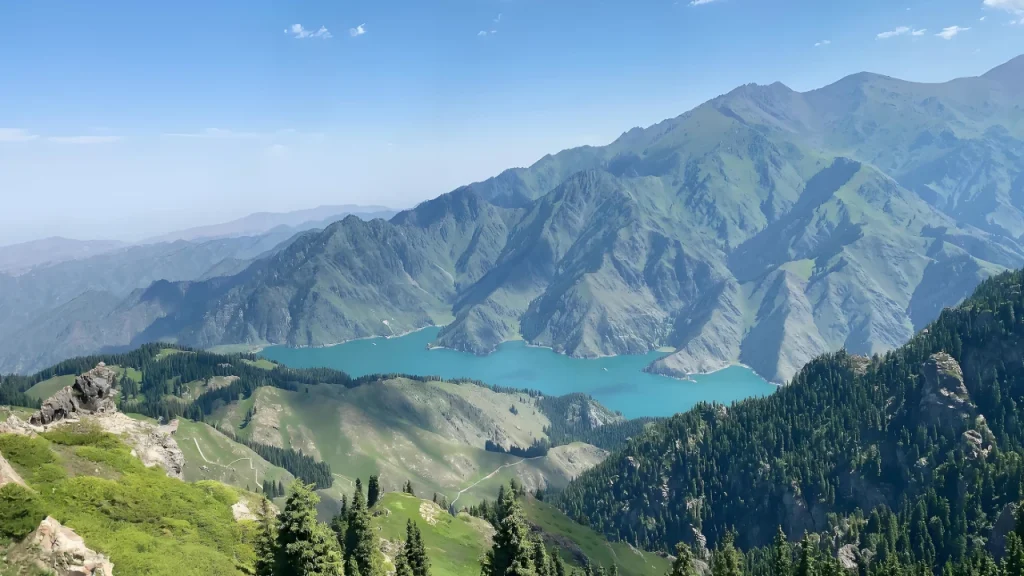
Centered around Tianchi Lake, the scenic area features four complete vertical natural landscape belts, with snow-capped glaciers and alpine lakes as its defining characteristics. Its cultural significance lies in the ancient Yaochi mythology and rich folk customs. This makes it a paradise on earth for sightseeing, scientific research, adventure tourism, outdoor recreation, and cultural immersion experiences.
On May 8, 2007, the Tianshan Tianchi Scenic Area was officially designated as a National AAAAA-Level Tourist Attraction by the China National Tourism Administration.
Historical Development
Tianchi Lake was historically known as “Yaochi” (Jade Pool). During the reign of Emperor Taizong of the Tang Dynasty, the “Yaochi Commandery” (an ancient administrative institution) was established at the foot of Bogda Peak.
In the 48th year of Emperor Qianlong’s reign (1783), Ming Liang, the Xinjiang Military Commissioner, conducted a terrain survey and hydraulic works at Bogda Mountain and Tianchi Lake, including quarrying stones and diverting watercourses.
In 2002, the Tianchi Management Committee initiated a comprehensive redevelopment plan, expanding the scenic area’s tourable zone from 158 square kilometers to the current 548 square kilometers.
Geographical Environment
Location and Boundaries
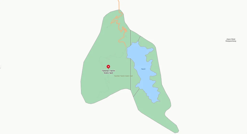
The Tianshan Tianchi Scenic Area is situated in Fukang City, Changji Hui Autonomous Prefecture, Xinjiang Uygur Autonomous Region. Covering a total area of 548 square kilometers (core zone: 311.37 km²), its geographic coordinates span from 88°00′45″ to 88°25′41″ east longitude and 43°44′56″ to 44°04′44″ north latitude.
Topography and Geomorphology
The Bogda Range, an eastern branch of the Tianshan Mountains, emerged from ancient seas during the Paleozoic era 280 million years ago. Marine uplift caused by Variscan Orogeny formed its primitive outline, with Yanshan Movement in the Mesozoic era causing secondary uplift. Significant block uplift during the Cenozoic era shaped the modern Bogda Range. Alternating glacial and interglacial periods drove intense erosion, creating a rugged mountain landscape with relative relief exceeding 500 meters. Above 3,500 meters, well-developed glacial landforms dominate, including cirques, arêtes, moraine fields, and rock glaciers. The main ridge extends eastward in a narrowing, descending band.
Climate Characteristics
Fukang City, where the scenic area is located, lies on the northern slope of the Tianshan Mountains and extends into the Junggar Basin hinterland. It belongs to the temperate continental arid and semi-arid climate zone.
Hydrological Features
The Bogda Range’s massive elevation (5,445 m) sustains extensive glacial resources. Its northern slopes contain 54 modern glaciers covering 4,482 hectares with total water reserves of 217 million cubic meters. Within the protected area, 32 glaciers occupy 1,702 hectares with 86.9 million m³ reserves.
Three river systems drain the area: Sangong, Sigong, and Shuimogou Rivers. Their flows depend on glacial/snow melt and exhibit strong seasonal variation – peaking in summer rainy seasons, diminishing in autumn, and reaching minimums in spring except for Sangong River, which maintains stable flow due to Tianchi Lake’s reservoir effect.
The protected area contains 12 lakes, including 9 small alpine glacial lakes. Only Tianchi Lake and the East/West Small Tianchi Lakes are located in the montane zone. Tianchi, the centerpiece, sits at 1,910 m elevation with:
- Surface area: 2.48 km²
- Maximum depth: 102 m
- Water volume: 160 million m³
Main Attractions
Tianchi Lake Scenic Area
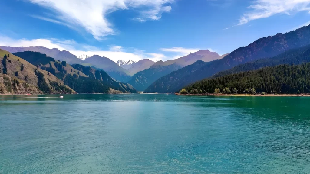
Tianshan Tianchi is the largest glacial dammed lake in the Tianshan Mountains and one of China’s most renowned deep freshwater lakes. Known historically as “Yaochi” (Jade Pool), “Shenchi” (Divine Pool), and “Longtan” (Dragon Pool), it sits at 1,910 meters elevation. The lake extends 3.5 km north-south, with widths varying from 350 to 1,500 meters. Key metrics:
- Surface area: 2.47 km² (max. 4.90 km²)
- Shoreline length: 10.98 km
- Average depth: 60 m
- Maximum depth: 103 m
- Water volume: 130 million m³ (max. 200 million m³)
- East Small Tianchi Lake
Also called “Black Dragon Pool” (Heilongtan), this lake at 1,875 m elevation has a triangular shape aligned along 115° azimuth. Measurements:
- Length: 180 m
- Width: 116 m
- Area: ~10,000 m² (Note: Possible data discrepancy – 10,000 km² would exceed Tianchi’s total area)
- Depth range: 40 cm (edge) to 10+ meters
- Length: 180 m
- West Small Tianchi Lake
Ancient name “Jade Maiden Pond” (Yunvtan) at 1,670 m elevation receives seepage from Tianchi’s northwest dam. Triangular in shape along 345° azimuth:
- Length: 158 m
- Width: 100 m
- Area: ~12,000 m² (Note: Possible data discrepancy – 12,000 km² would exceed Tianchi’s total area)
- Average depth: 1.5 m
- Depth range: 40 cm (shallowest) to 5 m
- Length: 158 m
Baiyanggou Valley Scenic Area
Located on the eastern side of the middle Sangong River Valley, the Baiyanggou Valley Scenic Area stretches approximately 20 km in length and covers 76 square kilometers. Characterized by river valleys, forests, and grasslands, it contains one scenic cluster and two attractions:
- Baiyanggou Scenic Cluster
- River Valley Forest Landscape
- Snow Lotus Cultivation Base
This region boasts exceptional biodiversity with dense growth of various trees and shrubs, making it a typical biodiversity hotspot on the northern slope of the Tianshan Mountains.
- Baiyanggou Valley
- The valley itself extends 20 km with an area of 30 square kilometers. As a biodiversity stronghold on the Tianshan’s northern slope, it supports over 200 plant species including endemic trees, shrubs, and herbaceous flora.
- The valley itself extends 20 km with an area of 30 square kilometers. As a biodiversity stronghold on the Tianshan’s northern slope, it supports over 200 plant species including endemic trees, shrubs, and herbaceous flora.
- Snow Lotus Cultivation Base
- In the mid-1990s, Xinjiang Tianshan Lotus Pharmaceutical Co., Ltd. invested over 20 million yuan to establish this base 10 km deep into Baiyanggou at 1,800 meters elevation. The project achieved successful artificial cultivation of the rare Saussurea involucrata (snow lotus).
Maya Mountain Scenic Area
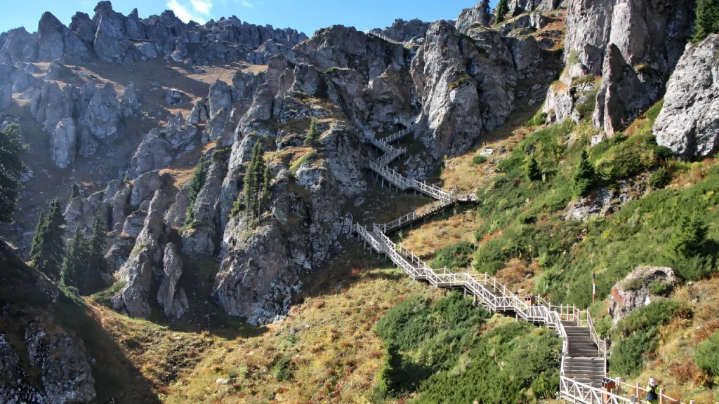
Located southwest of Tianchi Lake, the Maya Mountain Scenic Cluster features alpine stone forests and covers 16.69 square kilometers. It comprises Maya Mountain’s main peak and various rock formations resembling animals, offering activities such as mountain hiking, leisure fitness, scientific research, and panoramic viewpoints.
- Maya Mountain
- Situated approximately 4.5 km southwest of Tianchi Lake, Maya Mountain stretches 5 km in length with its main peak reaching 3,056 meters – the highest of the ten peaks surrounding Tianchi. From afar, the mountain’s jagged silhouette resembles rows of celestial horse teeth, hence its name “Maya” (horse teeth) or “Wanwu” (myriad peaks). The mountain receives abundant rainfall, supporting lush sedge grass in summer, which Kazakh herders call “Mayi Asan” meaning “Mountain of Sedge Grass”.
- Situated approximately 4.5 km southwest of Tianchi Lake, Maya Mountain stretches 5 km in length with its main peak reaching 3,056 meters – the highest of the ten peaks surrounding Tianchi. From afar, the mountain’s jagged silhouette resembles rows of celestial horse teeth, hence its name “Maya” (horse teeth) or “Wanwu” (myriad peaks). The mountain receives abundant rainfall, supporting lush sedge grass in summer, which Kazakh herders call “Mayi Asan” meaning “Mountain of Sedge Grass”.
- Celestial Dog Watching Lake Rock Formation
- Located southeast of Tianchi, this natural rock formation in the eastern Maya Mountain stone forest resembles a hunting dog intently gazing at the lake surface, earning its poetic name “Celestial Dog Watching the Lake”.
- Located southeast of Tianchi, this natural rock formation in the eastern Maya Mountain stone forest resembles a hunting dog intently gazing at the lake surface, earning its poetic name “Celestial Dog Watching the Lake”.
- Bayi Rock Formation
- On the western slope of Maya Mountain stands a massive boulder resembling a portly bayi (wealthy landowner) with arms embracing his belly, wearing a traditional chapan robe, long beard, and shoulder-length curly hair. Kazakh herders call this formation “Qikenbayi”, after a legend about a herder who became wealthy grazing his livestock here. After his death, he transformed into this stone guardian watching over his pastures.
Dengganshan Mountain Scenic Area
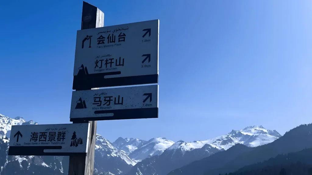
Located west of Tianchi Lake, the Dengganshan Scenic Cluster features typical mid-mountain forest landscapes and covers 27.23 square kilometers. It comprises Dengganshan Mountain, the Da/Xiaoguodipit glacial basins, and the Shanshenmiao Temple ruins.
- Dengganshan Mountain
Situated approximately 4 km west of Tianchi Lake, Dengganshan Mountain rises in a north-south orientation within the mid-mountain valley forest zone. Spanning 3 km in length and 2 km in width, its main peak reaches 2,718 meters – making it the second-highest peak west of Tianchi. The summit offers panoramic views:
- Eastward: Full vista of Tianchi Lake and Bogda Peak
- Southward: Distant view of Urumqi City
Historical records from the Fukang County Gazetteer note that two temples stood atop the mountain around 1928. Taoist priests erected a pine pole with a red lantern, symbolizing peace – hence the name “Dengganshan” (Lamp-Post Mountain).
- Eastward: Full vista of Tianchi Lake and Bogda Peak
- Da/Xiaoguodipit Glacial Basins
At the mountain’s base lie two ancient glacial erosion basins resembling giant cauldrons:
- Daguodipit (Large Cauldron-Bottom Pit)
- Elevation: 2,530 m
- Area: 125,000 m²
- Features: Three-sided steep cliffs (south/west/north), open east side
- Vegetation: Meadow floor with spruce forests on south/west slopes, sunny northern slopes with rolling grasslands
- Elevation: 2,530 m
- Xiaoguodipit (Small Cauldron-Bottom Pit)
- Elevation: 2,180 m
- Area: 36,800 m²
- Features: Perfect inverted square-cone shape, fully enclosed
- Environment: Serene glacial basin with Tianchi’s most picturesque forest meadows
- Elevation: 2,180 m
- Daguodipit (Large Cauldron-Bottom Pit)
Northern Desert Scenic Area
Located north of Fukang City, the Northern Desert Scenic Area is an enclave of the Tianchi Lake Scenic Area, featuring arid desert landscapes and Tang Dynasty heritage sites. It comprises two major scenic clusters and numerous attractions.
- Tang Dynasty Road
This 76.8 km long, 4 m wide ancient route stretches along the southern edge of the Junggar Basin, traversing Fukang City from east to west. As part of the New Northern Silk Road, it’s a municipal-level protected cultural relic. - Ancient City Sites
Near the infrastructure team of Fubei Farm (222nd Regiment) lies a Tang Dynasty city ruin bordered by saline flats to the east, residential areas to the southwest, and farmland to the north. Archaeological finds include:
- Grey pottery jars
- Painted pottery vessels
- Glazed ceramic bowls
- Three-eared painted pottery jugs
- Grey pottery jars
- Two early human settlement sites are also present:
- Gushahe Primitive Village Ruins
- Shatuliang Microlithic Site
- Gushahe Primitive Village Ruins
- Beacon Tower Ruins
Two significant beacon towers remain:
- Ziniquanzi Beacon Tower
- Location: 2.5 km south of Tang Dynasty Road in Ziniquanzi Town
- Features: Collapsed rammed earth structure, 9m residual height, circular base diameter 21m
- Artifacts: Grey and red sandstone ceramic fragments similar to Beizhuangzi Ancient City
- Alternate names: Akemunala Beacon Tower
- Location: 2.5 km south of Tang Dynasty Road in Ziniquanzi Town
- Wumi Tudui Beacon Tower
- Location: 150m south of Tang Dynasty Road in Xiquan Farm
- Features: Rammed earth construction, 5m residual height
- Status: Municipal-level protected relic
- Location: 150m south of Tang Dynasty Road in Xiquan Farm
- Ziniquanzi Beacon Tower
- Gurbantunggut Desert
China’s second-largest desert (48,800 km²) occupies the Junggar Basin center at 300-600m elevation. Comprising four sub-deserts:
- Sobugur Bugle Desert (west)
- Huojingnelixin Desert (east)
- Dezosoteng Ailsong Desert (central)
- Kobbei-Akekum Desert (north)
- Sobugur Bugle Desert (west)
- Wutonggou Valley
Located 30 km northwest of Fukang City, this shrub-dune area rises gradually from south to north. Natural vegetation barriers of tamarisk, haloxylon, and poplar trees prevent sand encroachment. In 2005, entrepreneur Tong Lixuan invested 4 million yuan to establish the Wutonggou Desert Tourism Station, utilizing the Forestry Bureau’s monitoring post, with daily capacity of 200 visitors.
Shuimogou Valley Scenic Area
Located south of Fukang City and west of the Sangong River, the Shuimogou Valley Scenic Area stretches 40 km in a north-south orientation, covering 84 square kilometers. The Shuimogou River has:
- Average annual runoff: 20.3174 million m³
- Mean annual discharge: 0.64 m³/s
Key attractions include:
- Duopozi Valley
Situated at the southern end of Shuimogou River, this 6 km-long alpine grassland valley features:
- Sloping meadows and river valley woodlands
- Lush broadleaf forests along streams – ideal summer retreat
- Sloping meadows and river valley woodlands
- Lugu Valley
Located at the head of Damaquan Valley, this 6 km-long winding canyon features:
- Steep cliffs and abandoned 1950s-era logging tracks
- Post-1998 logging ban: revived flora with blooming meadows and cascading springs
- Access route to Maya Mountain and Dengganshan Mountain trailheads
- Infrastructure upgrades: 12.8 million yuan invested in 2005 for Daguodipit-Zhikou Road (completed 2008)
- Steep cliffs and abandoned 1950s-era logging tracks
- Shuimogou Resort
Located 500m south of Fukang City at the Shuimogou River outlet, this complex includes:
- Yaowangdong Temple restoration project
- Agritourism facilities for rural leisure
- Yaowangdong Temple restoration project
Bogda Peak Scenic Area
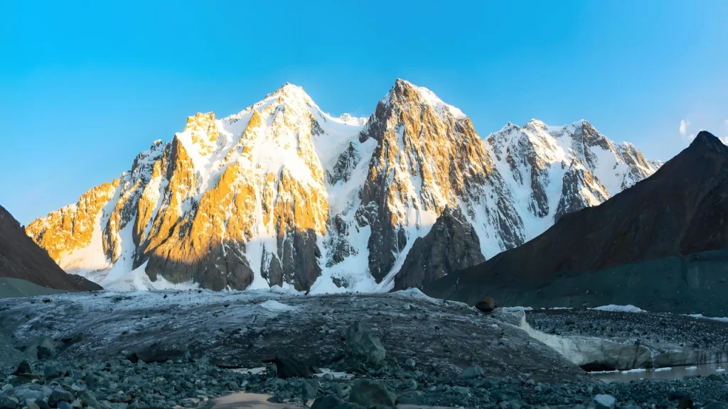
Located at the southeastern end of Tianchi Lake, the Bogda Peak Scenic Area spans 189.92 km² and features glaciers, snow peaks, and forest ecosystems. Characterized by towering snow mountains, rugged ice peaks, winding streams, and dense forests, it contains:
- Glacial landscapes
- Snow-capped peaks
- Meandering rivers
- Waterfalls
- Virgin forests
- Grassland wetlands
- Rock formations
- Petroglyphs
- Ancient burial sites
Comprising 3 scenic clusters and 8 attractions, this protected area (important glacial watershed) prohibits hiking/mountaineering since June 2008 per China’s Nature Reserve Regulations.
- Bogda Mountain
Known historically as:
- “Zheluoman Mountain” (Tang Dynasty)
- “Jinling” (Song Dynasty)
- “Yinshan” (Yuan Dynasty)
- “Lingshan” (Ming Dynasty)
- “Bokeda Mountain” (Qing Dynasty, Mongolian “Sacred Mountain”)
- “Zheluoman Mountain” (Tang Dynasty)
- Qing Emperor Qianlong canonized it as “Fushou Mountain” (Blessing & Longevity), with annual sacrifices held at Urumqi’s Hongshanzui by Xinjiang governors – equivalent to Five Great Mountains ceremonies. Post-1949, it was officially named “Bogda Peak” and became one of Xinjiang’s 11 open-access mountains.
- Geological features:
- Triple peaks resembling a writing brush holder (“Snow Sea Tri-Peaks”)
- Central peak: 5,445 m (highest)
- East peak: 5,287 m (“Spirit Peak”)
- West peak: 5,213 m (“Sacred Peak”)
- 113 glaciers storing 1.64 billion m³ ice
- 30+ rivers fed by meltwater, nourishing oases north/south Tianshan
- Tianchi Lake’s primary water source
- Triple peaks resembling a writing brush holder (“Snow Sea Tri-Peaks”)
- Geological features:
- Alpine Meadow Zone
Above 2,900 m elevation, these gentle slopes feature:
- Abundant seasonal snowmelt
- Cold-humid climate
- Kobresia-dominated sedges (Kobresia, Carex)
- Key species: Artemisia, Saxifraga, Leontopodium, Papaver, Stipa, Trollius
- Abundant seasonal snowmelt
- Subalpine Meadow Zone
Between 2,700-2,900 m elevation, these meadows contain:
- Kobresia, Carex, Geranium, Sabina
- Vibrant wildflowers: Alchemilla, Cymbalaria, Trollius, Anemone, Papaver, Crassula
- Kobresia, Carex, Geranium, Sabina
- Bogda Petroglyphs
Located at Sigong River Valley’s Lixingdaban southern end (3,500 m elevation), these extensive carvings cover an independent rock mountain adjacent to Sigong River’s western headwaters. The northwest/north slopes are wetlands. - Jiyanjian Petroglyphs
Found 18 km southeast of Tianchi Lake near Jiyanjian Valley’s snowline, these carvings appear on two south-facing black tuff rocks. - Sigong River Valley
This glacial valley 10 km east of Tianchi Lake remains in pristine condition. The Sigong River originates from Bogda Peak’s western glaciers, flowing 40 km south-north.
Tourist Information
Admission Fees
- Peak Season (April 1 – October 31):
- General admission: ¥95/person
- Shuttle bus: ¥60/round trip
- Total: ¥155/person
- Off-Peak Season (November 1 – March 31):
- General admission: ¥45/person
- Shuttle bus: ¥60/round trip
- Total: ¥105/person
Transportation
Public Transit
- Urumqi North Suburban Bus Station ↔ Fukang Bus Station
- Fare: ¥15
- Summer schedule (8:00-21:00) every 10 mins
- Winter schedule (8:40-19:30) every 10 mins
- Fukang Bus Station ↔ Tianchi Ticket Office
- Fare: ¥5
- Departures every 20 mins
Self-Driving Routes
- From Urumqi/Changji:
Take Turpan-Urumqi-Dahuangshan Expressway → Fukang Overpass → Continue 5km → Tianchi Overpass → Follow S111 Provincial Road to Ticket Office - From Qitai/Mulei:
Take Turpan-Urumqi-Dahuangshan Expressway → Tianchi Overpass → Follow S111 Provincial Road to Ticket Office
Recommended Tours
- Tour Route 1: Maya Mountain Cable Car
- Highlight: Panoramic views of Tianchi Lake and Bogda Glacier
- Itinerary: Take sightseeing bus to Maya Mountain base → Transfer to cable car
- Features: Multiple observation points, close-up views of Bogda Snow Peak
- Highlight: Panoramic views of Tianchi Lake and Bogda Glacier
- Tour Route 2: South Lake Cruise
- Highlight: Scenic boat ride with snow mountain views
- Itinerary: Board cruise ship → Sail south towards glaciers → Disembark at Xiwangmu Temple
- Features: Water spray effects, spruce forest observations, “painting-like” scenery
- Highlight: Scenic boat ride with snow mountain views
- Tour Route 3: East Trail Hiking
- Highlight: Virgin spruce forest trek with wildlife sightings
- Itinerary: Hike east from main lake → Pass through squirrel habitats → Discover wild mushroom clusters → Visit Feilong Waterfall (upper slower cascade & lower 100m plunge)
- Highlight: Virgin spruce forest trek with wildlife sightings
Leave a Reply